Share
The Centre spoke with Andrew Tatem, a UK-based academic and director of WorldPop which works to ensure that every person is mapped and counted in decision making. We discussed supporting national statistics offices with censuses and skill-building, the importance of geospatial data in humanitarian response, and the rapid pace of technological change in satellite detection.
This interview was conducted by Becky Band Jain, the Centre’s Communications Manager. It has been edited and condensed for clarity.
What does WorldPop do? Why was it formed?
WorldPop integrates different geospatial datasets to complement and improve the spatial detail and timeliness of population data, with a particular focus on low- and middle-income countries. We started with an initiative called AfriPop in 2004 and since then we’ve expanded globally. The issue that we were addressing is that traditional population data sources, such as censuses, are only updated every decade and are often outdated.
Can you give us some examples of your work with population data?
We support national statistics offices and UNFPA with population estimation in cases where there are challenges in undertaking a census, or there’s a need for geospatial population data to support the census process. We also work with population data to support maternal and newborn health activities through the Countdown to 2030 initiative, childhood vaccination in collaboration with GAVI and WHO, and a range of different other activities depending on who we’re working with.
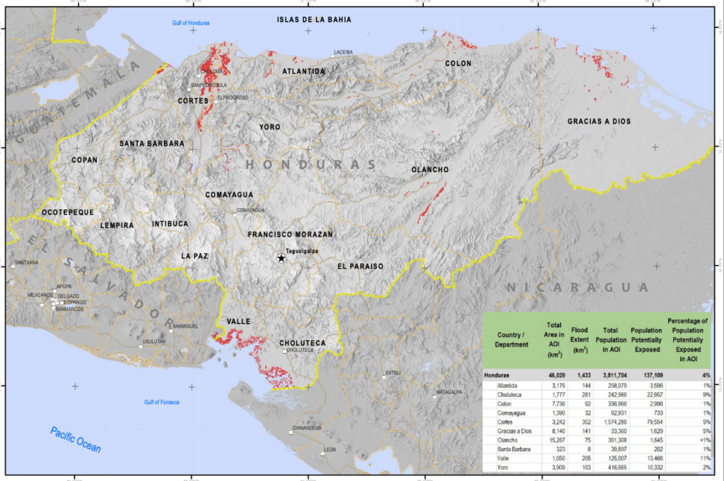
A lot of our work has been producing population datasets and putting them out there openly for anybody to use. One of the most widespread uses has been with UNOSAT and UNITAR whenever there is a natural disaster. Having gridded geospatial data has been valuable for undertaking a rapid assessment of the size of the population likely to be affected by an event so that things can start moving quickly on resource allocation and planning. (For example, see this recent dataset from UNOSAT on satellite-detected flooding in Honduras as a result of Hurricane Iota. Based on Worldpop spatial demographic data, about 140,000 people were estimated to be exposed or living close to flooded areas).
What is unique about your methods? What kind of insights does your data provide for humanitarians?
We have a set of methods to adapt to different data needs and uses, which we’ll cover in the upcoming deep dive with HDX on 9 December (register here). We have a menu of different types of population datasets and modelling methods which are broadly categorised as ‘top-down’ or ‘bottom-up’.
The top-down approach refers to taking census-based counts that are matched to administrative boundaries, turning those into grid cell estimates and maintaining those counts. In situations where there hasn’t been a census for 20 or 30 years and projections from that time are highly uncertain, we use the bottom-up approach. We use recent small area survey data that is cheaper and easier to collect than doing a full national census. Then, we link it with datasets like national mapping of building footprints and other geospatial datasets to estimate population numbers in the absence of a census. This work is largely undertaken through a multi-partner program called GRID3, supported by The Bill & Melinda Gates Foundation and the UK Foreign, Commonwealth and Development Office.
For our demographic mapping, we divide up the world into squares of 100 meters by 100 meters. And in each one of those squares, we are estimating how many people reside there. We also estimate how that changes over the years and sometimes even estimate population movement patterns and density changes by month by month. Depending on the needs, we look at characteristics of those populations like literacy, poverty rates or sanitation.
How is your organization working with HDX?
We’ve had a long-running collaboration since we have complementary aims in making data and methods as open as possible. Working with HDX has allowed us to reach many more people as well as receive feedback and connections for improved population data to then feed these back into our modelling. Sometimes, there are more detailed datasets out there that we don’t know about, or that need sharing agreements or discussions with governments. It’s a virtuous cycle of sharing data and getting feedback, improving it and putting it out again. Since we joined HDX in 2016, we have shared over a thousand datasets.
What are the challenges of working with humanitarian data?
Accurate population data for small areas is a vital resource. But in a humanitarian situation, things could be changing rapidly. It’s challenging to get accurate information and to incorporate whatever is coming from the field from surveys and other sources into our models, and to update them quickly to still be relevant and useful. If there hasn’t been a census for 20 or 30 years, it can be a major challenge to even get reliable baseline numbers.
As a global community, we’re often relying on data that is very outdated for some settings. That’s what directed our work recently towards developing methods for trying to estimate population distributions in the absence of census data.
There’s also a challenge of capacity strengthening. The ultimate aim is to put ourselves out of a job so that national statistics agencies or ministries of health can undertake this kind of mapping and modelling themselves. A large part of our work within the GRID3 program is communicating the value of these types of datasets and methods to decision makers who are often very busy. We’re trying to ensure that the right kind of skills are put in place and are sustainable by working with local academic organizations to ensure that they can support ministries. We aim to strengthen the capacity to utilize small area data, to update it, and to bring in geospatial datasets.
Lastly, population data underlies so much of decision making. That includes things like representation in parliaments and resource allocation. Population numbers therefore can be highly sensitive and contested. This is a challenge, particularly when we are producing new population estimates. We collaborate closely with governments so that they understand all the methods and how the data is going to be used as well as its limitations, ultimately with a goal that the country owns the outputs in the end.
Tell us about some of the trends you are seeing in the space.
There’s a rapid pace of technological development compared to 15 years ago when we started working on population mapping. We were working with satellite data, but the scale of the data meant we were only able to detect big cities and some small towns, limiting the accuracy of population maps. We had no real way of being able to locate small hamlets and isolated buildings.
Only in the last couple of years has technology advanced to be able to take very high resolution satellite images and accurately extract building outlines across entire countries. Building data has really pushed forward what can be done for population modelling in low-and middle-income settings. We now can use this data as valuable covariates and masks in our population mapping.
There’s also a trend in the use of spatial data in Geographical Information Systems and there are stronger skills within governments, which are realizing the power and potential of these kinds of methods and data. It’s really exciting to see. Whichever government we work with, there are always some highly-skilled people who can take the kinds of geospatial datasets we produce and work with them, which wasn’t the case ten or fifteen years ago.
What’s next for WorldPop?
The next six months to a year will involve continuing to document and publish all of our methods, as well as making available code and applications to use the datasets. As part of the GRID3 program and our collaborations with UNFPA, we are continuing to engage with more national statistics offices and other government ministries to support them with their census planning and producing estimates in the absence of a census.
We will focus on strengthening the capacity of national statistical offices and other government agencies to use these data and eventually produce and develop their own models. Previously we did a lot of in-person collaborations with statistics offices in different countries, so we’ve had to adapt to doing that as an online engagement. It is certainly more challenging.
What do you love about what you do?
Previously I was more of a standard academic, researching and publishing papers. What I love now is having close engagements with the decision makers who are using the data and affecting people’s lives with the way they’re using the data. It’s not just putting data out there and hoping that people are using it. We’re actively working with the policymakers, learning a lot ourselves from them and, ideally, passing on skills and seeing geospatial demographic data used to improve people’s lives.