Share
One of the first questions asked at the beginning of a humanitarian crisis is, “How many people are affected and where are they?” To answer that question, analysts start by looking for population statistics of the affected area. This data can be combined with data about storm tracks, flood extents, drought maps, shake maps, and conflict zones to provide estimates of how many people are affected and how severely.
However, in many countries, detailed population distribution data is not available. There may be national population estimates but they are not always broken down into the administrative units of a country. At WorldPop, we combine the most recently available census or official estimate data with a range of geospatial datasets to estimate the number of “people per grid square” in each roughly 100m by 100m grid cell.
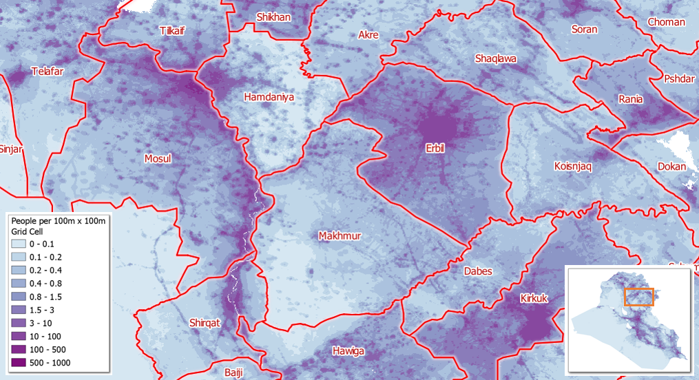 Estimated population per grid cell for Iraq. The estimated total population of each administrative unit (in red) is calculated by summing up the population values associated to all grid cells contained in it.
WorldPop has been working with the HDX team to overlay our gridded population estimates with the administrative boundaries of several countries. The boundary data is part of the OCHA-curated Common Operational Datasets (CODs), which can be found on HDX and are provided as machine-readable services by the University of Georgia. The goal is to produce simple tables of population estimates by administrative unit, which analysts can then easily import into their own tools.
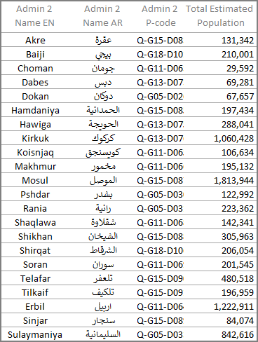
This table shows the estimated population totals for each administrative unit shown in the map above.
We have produced prototype datasets for 13 countries including Burkina Faso, Central African Republic, Chad, Egypt, Guinea, Iraq, Mauritania, Nigeria, Palestine, Senegal, Somalia, South Sudan, and Sudan. Below we explain the technical details and methodologies for how we produced the datasets which combine the gridded population datasets with the vector administrative boundaries.
We hope these datasets provide easy-to-use population estimates at the administrative division level which can be used both in preparing for and responding to humanitarian crises in countries where such level of spatial detail is not available from census or other sources. Additionally, we hope they will provide a point of comparison with other population estimates.
Technical details
The input WorldPop gridded population distribution datasets were developed using different methodologies depending on the data available for each country. WorldPop methodologies use statistical processes to distribute the population of a given census unit across the grid cells within that unit, based on geospatial features that are highly correlated with population presence and density.
The gridded population distribution outputs have been projected forward to 2015 using rural and urban growth rate estimates from the UN Department of Economic and Social Affairs Population Division. More detail on WorldPop’s methodologies can be found in Stevens et al. (2015), Sorichetta et al. (2015), Tatem et al. (2007), Linard et al. (2011 and 2012), and Gaughan et al. (2013).
The other input is the COD data representing the administrative boundaries for each country. We should note that in addition to CODs for adminisrative units, the humanitarian community also tries to identify a COD for population. The outputs of this project should not be considered part of the agreed CODs for population, but rather as a starting point if no COD is available, or as a point of comparison with other population datasets.
Combining the data
The WorldPop gridded population distribution datasets and the COD administrative boundaries are combined to calculate population estimates for each administrative unit. For each country, the vector-based administrative boundaries are gridded (rasterized) and aligned to the corresponding WorldPop gridded population distribution dataset. To ensure that the output tables will have the same total population per country as the input WorldPop dataset, the gridded administrative boundaries are clipped and/or filled to match the extent of the WorldPop gridded population datasets.
This process accounts for the differences in the extents of the census boundaries originally used to produce the WorldPop gridded population datasets, and the COD boundaries endorsed for use by the humanitarian community in the country. Population values for all grid cells within each administrative unit are then summed to calculate total population estimates.
The most spatially detailed, i.e., the smallest administrative divisions available for each country, are used for the summarizing process. Results are then aggregated to calculate the population estimates for the larger, less spatially detailed, administrative division levels in the hierarchy.
Limitations
The output population statistics are subject to any errors in the original census or official estimate data (including both the counts and the census boundaries), plus the error inherent in using a statistical approach to disaggregating administrative unit-based population counts to a regular grid of fixed spatial resolution, plus any error introduced by the expansion or contraction of the COD administrative boundaries as described above. The WorldPop datasets use the most spatially detailed and recent census or official estimate counts at the time of production, but new population data may have become available since production, leading to differences in totals from these newer data.
Future development
If HDX users find these population tables useful, we could add all 30 countries currently available from the COD web service (as of June 2018). Some consideration will need to be given to how we handle countries with very large differences between the input census units and the COD administrative units (e.g., in cases where there are disputed territories). Additionally, we would like to further automate the process so that updates to the COD administrative units datasets or to the WorldPop gridded population datasets would trigger an update to the population tables. Another possible future development could include generating age and sex disaggregated population summaries.
If you would like to learn more or provide feedback, please contact us at A.J.Tatem@soton.ac.uk or A.Sorichetta@soton.ac.uk. You can contact the HDX team at hdx@un.org or via @humdata on Twitter.